


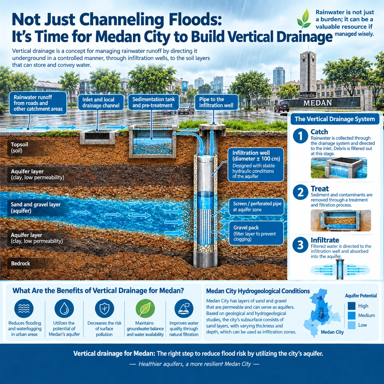
Medan, September 13, 2026 — Every time heavy rain hits the city of Medan, the same question almost always arises: where should the water be directed?
So far, the answer has always been drainage channels, rivers, retention ponds, or other surface water bodies. While this approach remains important, challenges emerge as the urban landscape becomes increasingly paved with concrete and asphalt, leaving limited space to expand existing drainage networks.
Perhaps it is time to look at flood management from a different angle: not just conveying water horizontally, but managing it vertically.
This idea forms the basis of the Medan Vertical Drainage System (MVDS)—a vertical drainage concept that utilizes specific aquifer layers as receiving media for treated stormwater runoff.
The concept can be realized through deep groundwater recharge wells. The core principle is not to dump floodwaters raw into the ground, but rather to capture a portion of the runoff, treat it, and inject it into suitable aquifer formations.
This system is particularly relevant for Medan. Studies on groundwater recharge in the city have highlighted the potential of recharge wells to mitigate localized flooding. For instance, research conducted by engineering lecturers at Universitas Sumatera Utara (USU) in the Bandar Selamat area revealed a runoff volume of approximately 1,008 liters per second against an existing channel capacity of around 886 liters per second. This capacity deficit demonstrates that under heavy rainfall, current drainage infrastructure simply cannot handle the total volume.
This is precisely where vertical drainage can step in.
Conceptually, recharge wells of specified diameters can be installed in flood-prone areas. Their depths do not need to be uniform; drilling must navigate subsurface layers guided by geological and hydrogeological investigations, ultimately targeting permeable strata—such as sand or gravel—that possess high water-reception capacities.
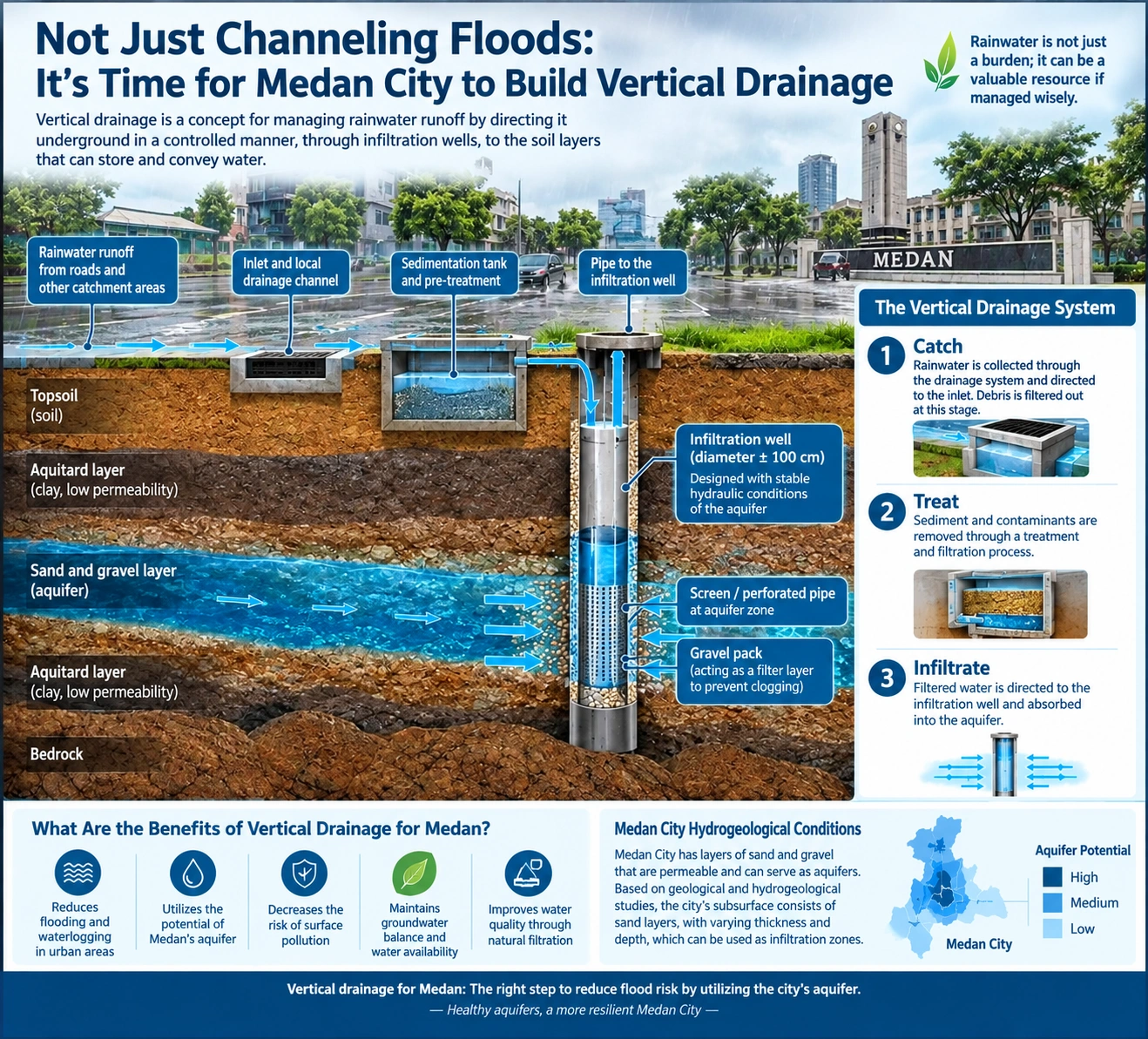
Within these aquifer intervals, screens or perforated pipes surrounded by a gravel pack can be installed. Pre-treated water then flows into permeable formations and disperses through intergranular pore spaces. Through this approach, a portion of rainwater is diverted from immediate surface runoff and returned to the underground water system.
This concept is scientifically known as enhanced aquifer recharge or managed aquifer recharge. The U.S. Environmental Protection Agency notes that stormwater can be harvested to replenish aquifers using various infrastructure models, including dry wells, infiltration galleries, and injection wells. However, the system's success heavily depends on local geological and hydrogeological conditions, clogging risks, land-use characteristics, and the quality of water injected underground.
Crucially, the success of this technology is not determined by well diameter or depth alone. The single most vital parameter is the receiving capacity of the aquifer itself. Consequently, every location must undergo prior assessment via geoelectric surveys, exploratory drilling, well logging, groundwater table measurements, permeability testing, and aquifer tests. The results of these studies determine the viable location, depth, screen intervals, and density of the wells to be constructed.
An even more critical aspect is water quality. Urban runoff often carries sediment, oil, heavy metals, organic matter, and various contaminants. Directing polluted water into aquifers without treatment risks creating severe environmental hazards underground. Therefore, the system must incorporate a capture, treat, and recharge sequence. Runoff is collected from inundated areas, routed through settling basins and filtration or pre-treatment units, and only then directed into the recharge wells.
Vertical drainage is not a replacement for traditional drainage channels, rivers, or retention ponds; rather, it acts as an additional layer in urban flood control infrastructure. Channels continue to convey flow, retention ponds absorb peak discharges, and recharge wells reduce runoff volume while simultaneously replenishing groundwater reserves.
The Medan City Government could initiate this approach through pilot projects at high-priority flood points. Each site should be selected based on catchment area size, inundation characteristics, existing drainage capacity, subsurface lithology, groundwater levels, and aquifer potential. Well performance can then be monitored via inflow rates, infiltration duration, groundwater level fluctuations, and water quality metrics.
The concept is straightforward, yet it offers a crucial paradigm shift: rainwater does not always need to be rushed out of the city as quickly as possible. A portion of it can be managed locally, purified, and responsibly returned to the hydrogeological system.
It is time for Medan to move beyond merely building drainage to flow floodwaters away, and start building vertical drainage systems to manage rainwater from the surface down to the subsurface.