


.webp)
Lubuk Pakam – Academics from the Faculty of Engineering, Universitas Sumatera Utara (FT USU), in collaboration with the Regional Development Planning, Research, and Development Agency (Bappedalitbang) of Deli Serdang Regency, presented a comprehensive technical study titled "Disaster Mitigation-Based Development Study of Sunggal District: Toward a Resilient Urban Buffer & Gateway" on Tuesday, October 27, 2026, at the Bappedalitbang Hall in Lubuk Pakam.
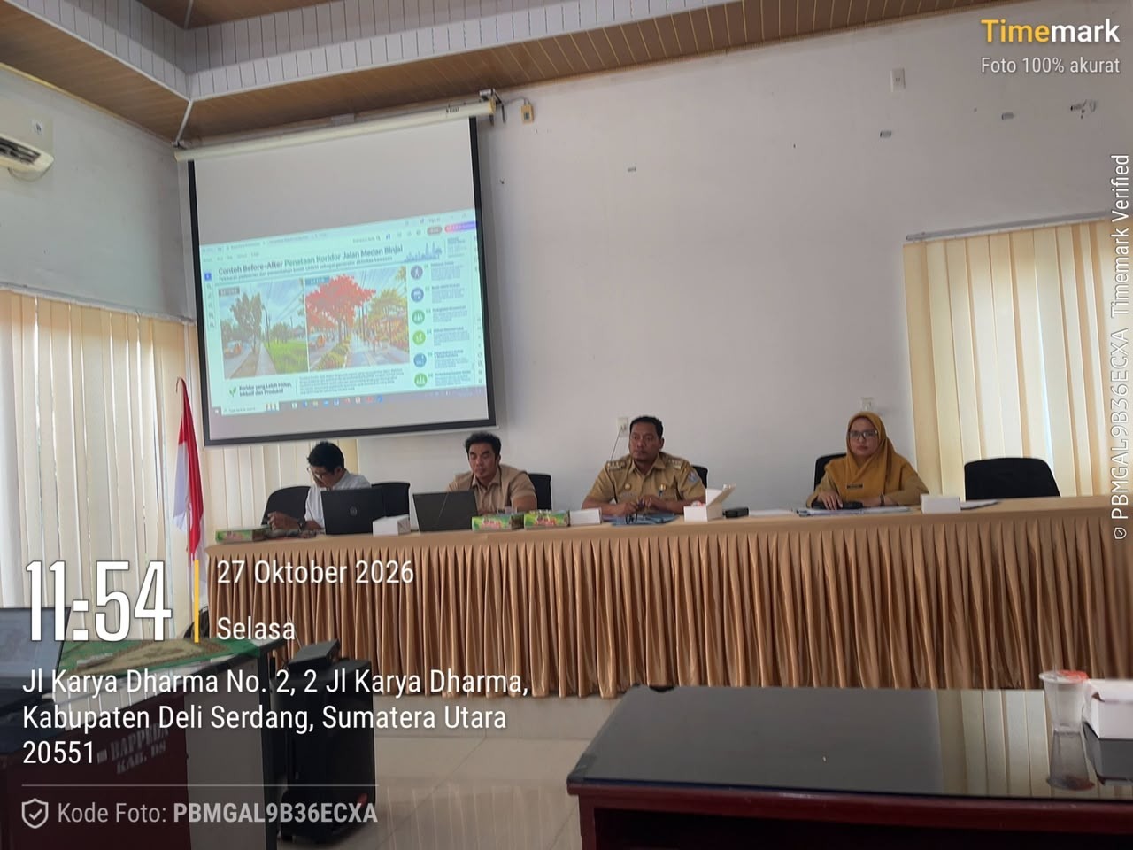
The technocratic forum was officially opened by the Secretary of Bappedalitbang Deli Serdang alongside the Head of Sunggal District. It was attended by technical Regional Government Agencies (OPD), including Cipta Karya and Spatial Planning, Water Resources and Construction (SDABMBK), Housing and Settlement, Environmental Services (DLH), Regional Disaster Management Agency (BPBD), Transportation, Agriculture, Cooperatives and MSMEs, as well as Industry and Trade.
The study was presented by two FT USU academics combining macro-spatial and micro-urban design dimensions: Dr. Anthoni Veery Mardianta, S.T., M.T. from the Urban and Regional Planning Program, and Dr. Ir. Ar. Achmad Delianur Nasution, S.T., M.T. from the Architecture Program.
Dr. Anthoni Veery Mardianta highlighted Sunggal District's strategic positioning within the Mebidangro Metropolitan Spatial Plan as a Regency Strategic Area (KSK) and a Transit-Oriented Development (TOD) node. However, spatial analysis revealed rapid urban sprawl between 2020 and 2025, with settlement areas increasing by 18.5% and industrial zones by 23.4%, converting agricultural land and green open spaces.
Despite 95.3% of Sunggal having high land-workability topography, 60.9% possesses low natural drainage capacity within the Belawan River Basin (DAS Belawan), leading to high flood vulnerability across 18.7% of the district and extreme weather vulnerability across 93.4%. To resolve these spatial paradoxes across its 8,015.28 hectares, Dr. Anthoni structured three integrated spatial orientations:
Sunggal as an Urban Buffer: Controlling rapid urban expansion via compact development while preserving agricultural and hydrological absorption functions (allocating 21.2% as Protected Areas).
Sunggal as a Gateway: Strengthening regional transportation connectivity across residential, commercial, and industrial corridors (allocating 78.8% as Development Areas).
Sunggal as a Disaster-Resilient Zone: Prioritizing flood risk reduction, Belawan River ecosystem protection, and drainage infrastructure upgrades.
Translating macro plans into micro-scale urban design, Dr. Achmad Delianur Nasution detailed masterplan interventions targeting key spatial blocks and linear corridors:
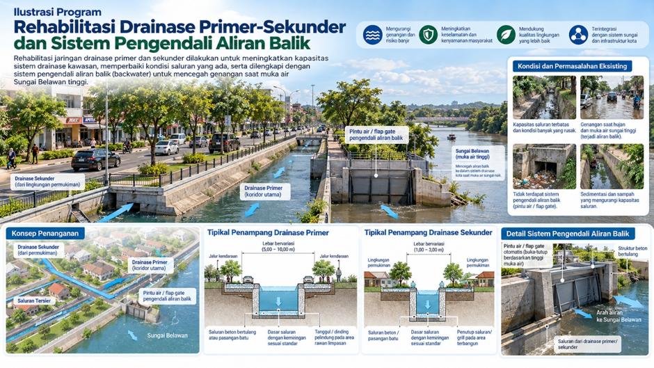
Belawan River Corridor: Integrating landscape architecture with ecological hydraulic engineering, featuring reinforced concrete and geotextile retention dykes, 3–5 meter waterfront greenways with inspection paths, selective sediment dredging, and automatic flap gate backwater systems on residential drainage outlets.
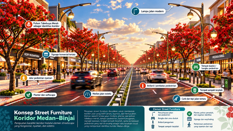
Medan–Binjai Road Corridor: Revitalizing the right-of-way into an inclusive urban boulevard framed by a signature Tabebuya Merah tree landscape, 3–4 meter universal accessibility pedestrian walkways with bioswales, Malay-themed smart street furniture, modular MSME booths, and active commercial frontages.
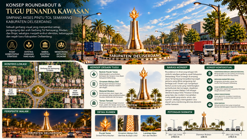
Landmark Gateways: Designing iconic regional entrance structures and a "Pucuk Tunas" roundabout monument near the Semayang toll gate, blending natural stone, architectural LED lighting, and traditional Malay ornamental motifs.
This interdisciplinary collaboration between urban planning and architectural design underscores FT USU's intellectual contribution to fostering disaster-resilient, culturally grounded, and economically vibrant metropolitan growth.
This strategic spatial planning collaboration directly supports Sustainable Development Goals SDG 9 (Industry, Innovation, and Infrastructure) by designing resilient urban infrastructure and sustainable transport corridors, SDG 11 (Sustainable Cities and Communities) by implementing disaster risk reduction and green urban design in peri-urban areas, and SDG 17 (Partnerships for the Goals) through multi-stakeholder governance between higher education researchers and regional municipal authorities.